
Appearance
Feature Selection & Popup
Clicking the map is how you ask what is there. With the Pointer tool on, a click goes off and asks every layer that can answer, highlights what it finds, and shows you the record in a small window on the map.
What a click asks
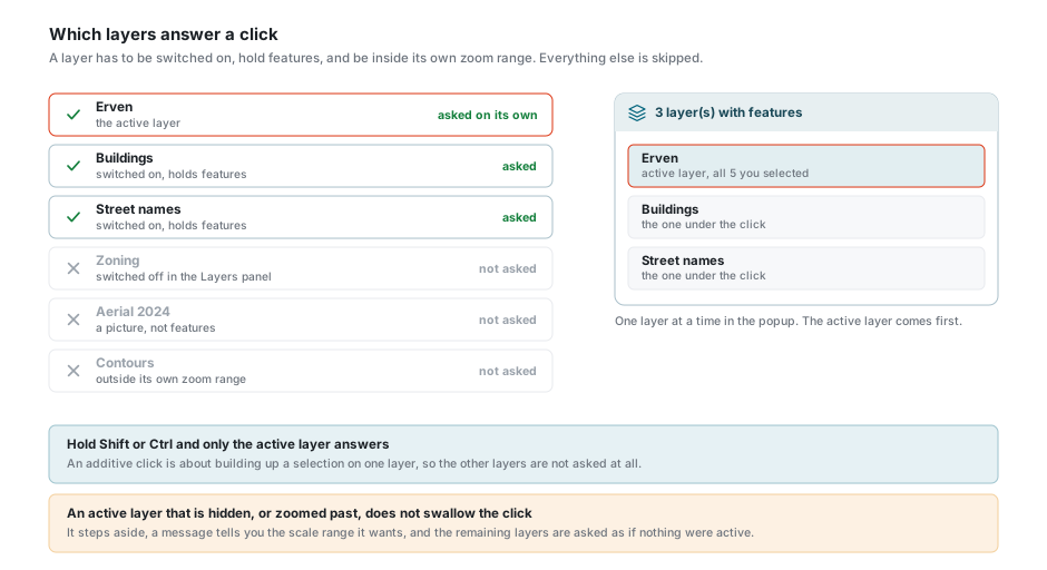
A layer is asked only when all three of these are true:
- it is switched on in the Layers panel;
- it holds features, not a picture. Aerial photography, scanned plans and other image layers are never asked;
- the map is inside the zoom range that layer was given.
The active layer is asked on its own, separately from the rest, and its answer is the one that carries the most:
- everything it finds is selected on the map and lands in the Data Table;
- it is the layer you can edit, page through, and use the layer tools on;
- it comes first in the popup.
Every other layer that qualifies is asked together with the others, and each contributes the one feature under your click.
Selected features are outlined on the map in your selection colour, which you set from the swatch at the top of the Layers panel. The one the popup is showing gets a heavier outline than the rest, and a feature belonging to a layer that is not the active one is outlined in a different colour so you can tell the two apart.
No active layer set?
The click still works. Every layer that qualifies is asked and you can read whatever comes back. What you lose is editing and the tools that need to know which layer you mean. See the active layer.
An active layer you cannot see does not swallow the click
If the active layer has been switched off, or you have zoomed outside its range, it steps aside rather than failing. A message tells you the scale range it wants, and the remaining layers are asked as if nothing were active.
Selection Modifiers
| Action | What it does |
|---|---|
| Click | Clears what was selected and selects what is under the click. Every layer that qualifies is asked. |
| Shift + Click | Adds to the selection instead of replacing it. Active layer only. |
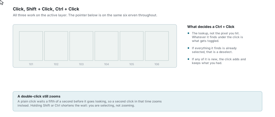
| Ctrl + Click | Adds too, but clicking something already selected takes it back out. Active layer only. |
| Ctrl + Drag | Draws a circle and selects everything of the active layer inside it. See Radial Selection. |
| Ctrl + Shift + Drag | The same circle on a line layer, keeping only the lines that neighbour nothing. |
Hold Shift or Ctrl and only the active layer is asked. An additive click is about building up a selection on one layer, so there is nothing to gain by asking the others.
What a Ctrl + Click actually toggles
Not the pixel you hit, but whatever the lookup finds under the click. If everything it finds is already selected, that is a deselect. If any of it is new, the click adds and keeps what you had. It is why a Ctrl + Click near the edge of a selected feature sometimes picks up the neighbour instead of dropping the one you meant.
A plain click waits about a fifth of a second before it goes looking, so a second click inside that time is read as a double-click and zooms instead. Holding Shift or Ctrl shortens the wait, because you are selecting rather than zooming.
Radial Selection
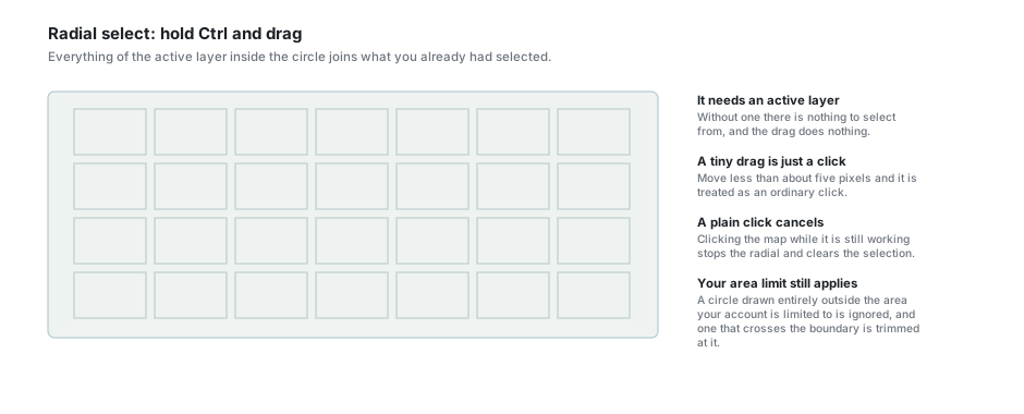
Hold Ctrl and drag. A red circle grows out from where you pressed. Let go, and everything of the active layer inside it is added to whatever you already had selected.
Worth knowing:
- It needs an active layer. Without one the drag does nothing.
- A drag of less than about five pixels is treated as an ordinary click.
- While it works, a panel at the bottom of the map counts the features in. Cancel stops it where it is, and so does clicking the map.
- If your account is limited to an area, a circle drawn entirely outside that area is ignored, and one that crosses the boundary is trimmed at it.
- If the layer has a Radial Select Filter, that filter decides what is eligible. See Data Table.
Lines that neighbour nothing
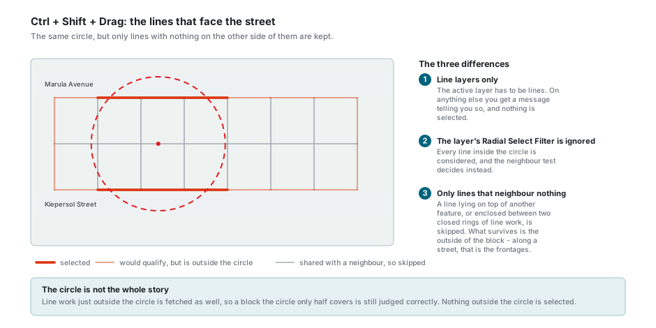
Hold Ctrl + Shift and drag, and the circle comes up dashed. It works like radial selection, with three differences:
- It only works on Line String / Multi Line String layers. On anything else a message says so and nothing is selected.
- The layer's Radial Select Filter is ignored. Every line inside the circle is considered, and the neighbour test decides instead.
- Only lines that neighbour nothing are kept. A line lying on top of another feature, or enclosed between two closed rings of line work - the boundary shared between two erven, say - is skipped. What survives is the outside of the block, which along a street is the frontages.
The line work just outside the circle is fetched as well, so a block the circle only half covers still comes out right. Nothing outside the circle is selected.
The feature popup
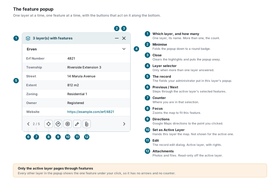
The popup is anchored to the point you clicked. Its header says which layer you are looking at when only one answered, and how many layers answered when there were more.
Inside it is the record: the fields your administrator chose for this layer's popup, in the order they chose. Links, photographs, dates, colours and tick boxes are all shown as what they are rather than as raw text, and a photograph opens the gallery when you press it.
Footer Buttons
| Button | What it does |
|---|---|
| Previous / Next | Steps through the features you have selected on the active layer. Not shown for any other layer. |
| Focus | Zooms the map to fit this feature. |
| Directions | Opens Google Maps directions to the point you clicked, in a new tab. |
| Focus on Street View camera | Only while Street View is open. Takes the map to where the camera is standing, and minimises the popup so you can see it. |
| Set as Active Layer | Hands this layer the map, and keeps the feature selected as it goes. Not shown for the layer that is already active, nor for a layer that cannot be made active. |
| Edit | Opens the record edit dialog. Needs the active layer, an edit template, and permission to change the layer. |
| Attachments | Opens Attachments for this feature. Always there, but read-only for a layer that is not the active one. |
Moving between layers
When more than one layer answered, the header shows the count and a chevron opens the list. Pick a layer and the popup shows its feature, highlighted on the map in the second colour.
Switch a layer off in the Layers panel while the popup is open and that layer drops out of the popup there and then. Switch off the last one and the popup closes.
Moving between features
The arrows and the counter belong to the active layer alone. Every other layer contributes a single feature, so it has neither.
- The counter reads
2 / 5, so you always know where you are. - The arrows wrap around from the last feature back to the first.
- Each step highlights the new feature and moves the Data Table to the same row.
- If the next feature is off the screen, the map slides to it first.
- Stepping away from a record you have edited but not saved asks first, and cancelling puts you back on the feature you were on.
Where the popup puts itself
You do not move the popup. It works out where to sit each time the view changes:
- Normally it sits just above the point you clicked, with a small tail pointing down at it.
- If it would cover the feature, or fall outside the map, it moves and draws a dashed arrow back to the feature instead of the tail.
- If the feature is off the edge of the map, the popup is held inside the edge and the arrow points out at it.
- While you drag the map the arrow is hidden, and it is redrawn when you let go.
Minimising it
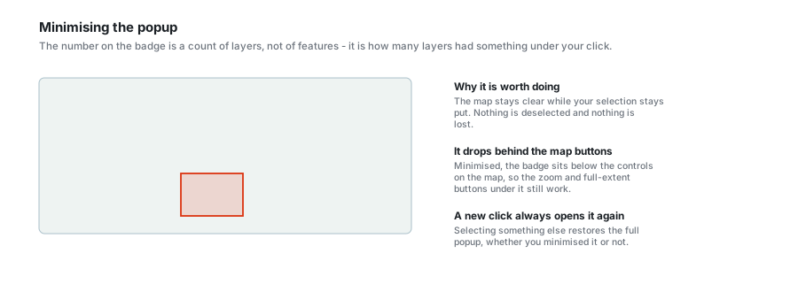
The minus in the header folds the popup down to a small round badge. Nothing is deselected and nothing is lost - press the badge and the popup opens again on the same feature.
The number on the badge is a count of layers, not of features: it is how many layers had something under your click. Minimised, the badge sits below the buttons on the map, so anything underneath it still works.
Selecting something else always brings the full popup back, whether you minimised it or not.
Turning the popup on and off
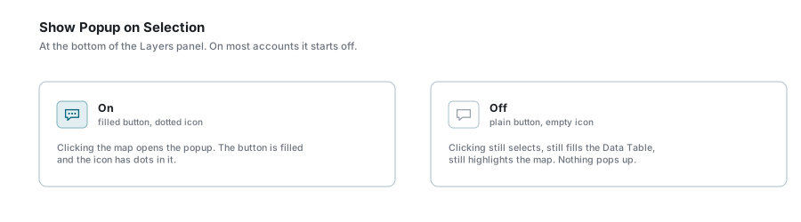
Show Popup on Selection is at the bottom of the Layers panel, and on most accounts it starts off. With it off, clicking still selects, still fills the Data Table and still highlights the map. There is simply no window. See the three toggles at the bottom.
If something looks wrong
| What you see | What it means |
|---|---|
| Clicking the map does nothing at all | Another tool has the map. Press Pointer on the toolbar above the map. |
| Nothing pops up, but the map does highlight | Show Popup on Selection is off. It is at the bottom of the Layers panel. |
| A message about the scale, and no selection | The active layer is not drawn at this zoom. The message names the range it wants. |
| A layer you can see is not in the popup | It holds a picture rather than features, or it is drawn but outside the range it was given for answering clicks. |
| "No features found at this location" | Nothing that qualifies was under the click. Try again on the feature itself rather than beside it. |
| Shift or Ctrl clicking finds nothing on other layers | That is deliberate. An additive click only asks the active layer. |
| No arrows or counter in the popup | You are looking at a layer that is not the active one. Those belong to the active layer's selection. |
| No pencil on the popup | The layer is not the active one, no edit template is chosen, or you do not have permission to change it. |
| Ctrl + Drag does nothing | No active layer is set, or the drag was too short and was read as a click. |
| "Special radial select only works on line layers" | Ctrl + Shift + Drag needs a line layer to be active. |
| The radial select is taking a long time | Watch the counter at the bottom of the map. Cancel stops it, and so does clicking the map. |
| Ctrl + Click dropped the wrong feature | It toggles what the lookup finds, not the pixel you hit. Zoom in and try again on the middle of the feature. |
| The popup is not where the feature is | It has moved so as not to cover it. Follow the dashed arrow. |
See also
- Layer Control - the active layer, the selection colour, and the popup toggle
- Data Table - where the active layer's selection lands
- Map Tools - the Pointer, and everything else on the toolbar
- Attachments - what the paperclip opens
- Editing Records & Spatial Data - what the pencil leads to