
Appearance
Export Layers
Exporting takes records out of a layer and hands you a file: a shapefile for your GIS, a spreadsheet, a KML for Google Earth. Nothing is downloaded at the moment you ask. The wizard collects your answers, the server does the work as a background job, and you fetch the file when it is ready.
Opening the wizard
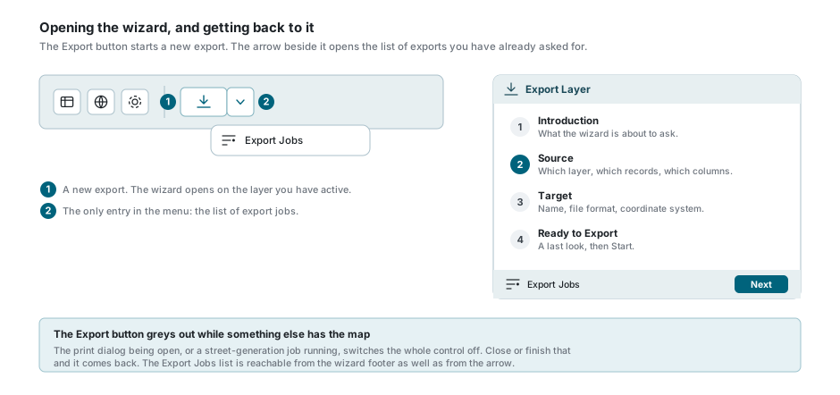
Press Export on the toolbar above the map. The wizard opens on the first of four steps, with the layer you have active already chosen and that layer's current filter already selected. If the data table is narrowed in any other way, the wizard starts out narrowed the same way. See What the wizard takes from the data table.
The arrow beside the button has a single entry, Export Jobs, which opens the list of exports you have asked for before. The wizard's own footer carries the same button, so the list is never more than one press away.
The Export button is greyed out
The print dialog being open, or a long map job running, switches the whole control off. Close or finish that and it comes back. On a phone the toolbar is not shown at all.
Which layers you can export
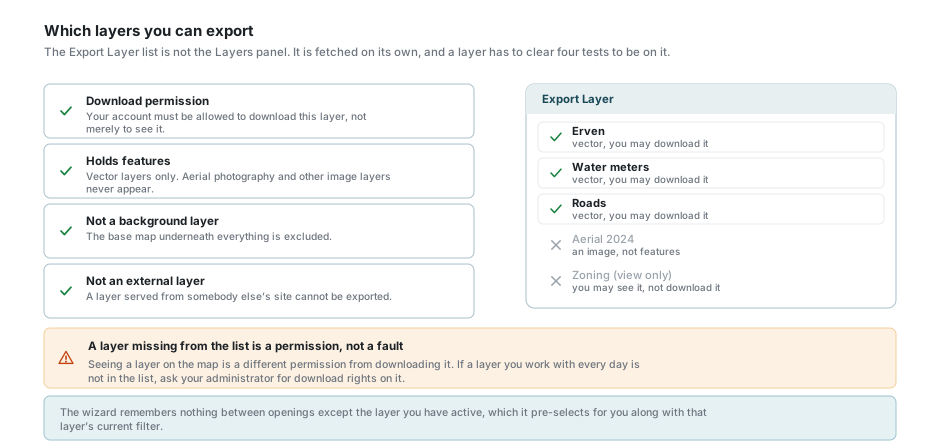
The list inside the wizard is not the Layers panel. It is fetched separately, and a layer reaches it only when all four of these are true:
- your account has download permission on it, which is a different permission from being allowed to look at it;
- it holds features. Aerial photography, scanned plans and other image layers are never in the list;
- it is not the background layer that sits under everything else;
- it is not an external layer served from somebody else's site.
A layer you work with every day can therefore be missing from this list. That is a permission, not a fault. Ask your administrator for download rights on it.
Step 1 - Introduction
The first step only describes what the wizard is about to ask for. Press Next.
Step 2 - Source
This is where you say which layer, and which of its records.
| Control | What it does |
|---|---|
| Export Layer | The layer to export. Type to narrow the list. |
| Filter | One of the layer's saved filters. Only shown when the layer has any. |
| Apply the data table's column filters | Only shown while the data table is filtering this layer. See What the wizard takes from the data table. |
| Only records without a location (Ungeocoded) | Only shown while the data table's Ungeocoded button is on. See What the wizard takes from the data table. |
| Export Columns | Which columns to write. See Export Columns. |
| Search | Narrows the export the way the data table's search box narrows the table. See The Search box. |
| Using extent | Which records. See Choosing which records. |
| Include linked attachments | Only shown when the layer has attachments. See Including attachments. |
The Filter box does not start empty. When you are exporting the layer you have active, it arrives holding whatever filter that layer is showing on the map. For any other layer it arrives holding that layer's default filter. No Filter is the first entry in the list, and choosing it exports the layer unfiltered.
The Search box
What the box does depends on what you leave in it.
| In the box | What is exported |
|---|---|
| Text you typed | The records the data table's search box would list for the same text. The suggestions under the box are a preview of them. |
| A suggestion you picked | Only the records that carry exactly that value. A typed Erf 12 also finds Erf 123; the picked suggestion Erf 12 does not. |
An expression, such as [status] = 'Active' | The records the expression matches. A column name in square brackets is what makes it an expression. |
When you are exporting your active layer, the box arrives holding whatever is typed into the search box above the data table. Empty it to export past that search.
If an expression names something that is not a column of the layer, pressing Start shows a message saying which, and nothing is started.
What the wizard takes from the data table
When the data table is filtering the layer you are exporting, a tickbox appears under Filter: Apply the data table's column filters. It makes no difference how the table came to be filtered. The boxes under its column headings, the Advanced Filter and one of your own saved filters all count. The tickbox arrives ticked, and the line beneath it names the columns being filtered on.
Left ticked, the file holds the records the data table is listing. Clear it and the export looks past those filters, so the file also holds records the table is not showing.
The rest of what can narrow the data table becomes the wizard's starting answer for the control that says the same thing here:
| In the data table | In the wizard |
|---|---|
| Text in the search box | Fills Search. |
| The Visible button | Visible extent is chosen. |
| The Selected button | Selected Features is chosen, when something is selected. It wins over Visible when both are on. |
| The Ungeocoded button | A tickbox appears, Only records without a location (Ungeocoded), already ticked, and All Features is chosen. |
Records without a location are not on the map, so no area can hold them. That is why ticking the Ungeocoded tickbox chooses All Features, and why choosing any other extent unticks it, exactly as the buttons behave in the data table.
All of this belongs to your active layer alone. Choose a different layer under Export Layer and the tickboxes disappear and Search empties, because the data table says nothing about that layer. They are starting answers, not locks: change any of them before you press Next. Filter and your account's own limits still apply on top.
Choosing which records
| Option | What is exported |
|---|---|
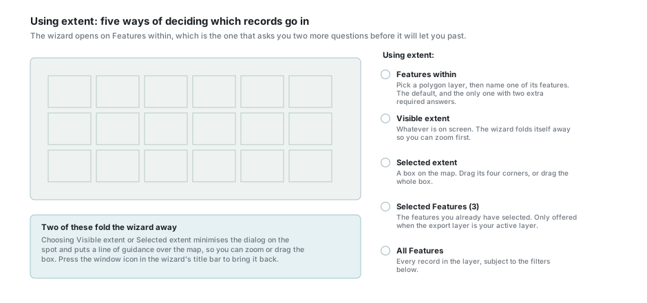
| Features within | Everything that falls inside one named feature of another layer. You pick a polygon layer, then name one of its features. This is the option the wizard starts on unless a button in the data table chose another, and Next will not move until you have answered both. |
| Visible extent | Everything inside the map area currently on screen. |
| Selected extent | Everything inside a box you draw on the map. Drag any of its four corners to resize it, or drag the middle to move the whole box. |
| Selected Features | Only the features you already have selected, with the count in the label. Offered only when the layer you are exporting is your active layer and something is selected on it. |
| All Features | Every record in the layer, wherever the map happens to be. |
Choosing Visible extent or Selected extent folds the wizard away on the spot and puts a line of guidance over the map, so that you can zoom or drag the box with the dialog out of the way. Press the window icon in the wizard's title bar to bring it back. When the wizard chose Visible extent itself, because the data table's Visible button is on, it stays open.
If you clear your map selection while Selected Features is chosen, the option disappears and the wizard quietly moves you back to Features within. Check the option before you press Next.
Export Columns
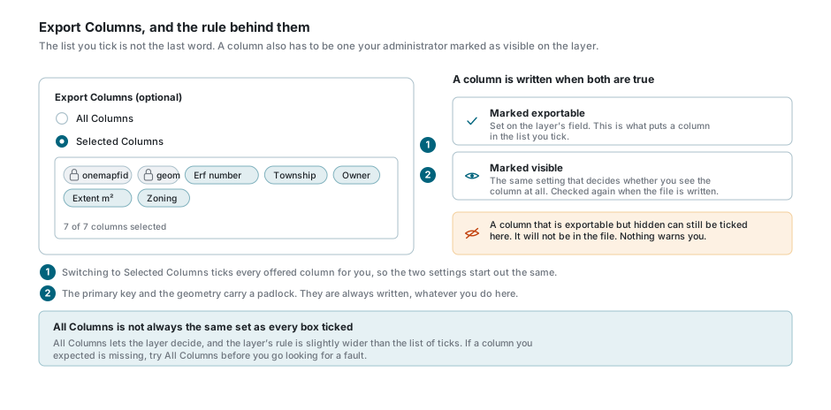
The default is All Columns. Switch to Selected Columns and every column the wizard can offer is ticked for you, ready for you to take some out.
Two of them cannot be taken out. The layer's primary key and its geometry carry a padlock, because without them the file could not be joined back to anything or drawn on a map.
A column reaches the file only when it is marked exportable and marked visible on the layer. The list you tick is built from the first of those two alone, so a column that is exportable but hidden can be ticked here and still be absent from the file, with nothing said about it. If a column you expected is missing, try All Columns first, then ask your administrator whether that column is visible on the layer.
Including attachments
When the layer has attachments, a switch appears with a count beside it. Switch it on and those files are packaged into the same zip as the features.
The wording of the count tells you how firm the number is. "12 on the selected features" is exact. "12 attachments" is exact for the whole layer. "up to 12 on this layer" and "12+ on this layer" are estimates, made when the layer is too large to count precisely or its data could not be read just then. Whatever the count says, the export itself packages exactly the attachments belonging to the records it actually exported.
Step 3 - Target
Name arrives filled in as the layer's name followed by today's date. It is what the downloaded file will be called, so change it to something you will recognise in a month.
The format list
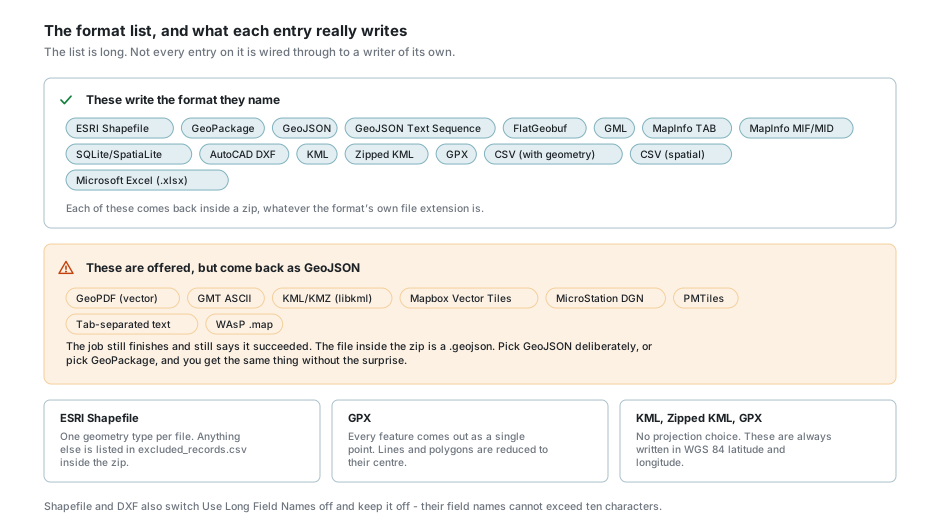
Eight entries in the list do not write the format they name
GeoPDF (vector), GMT ASCII, KML/KMZ (libkml), Mapbox Vector Tiles, MicroStation DGN, PMTiles, Tab-separated text and WAsP .map are offered, but the export writes GeoJSON for all eight. The job still finishes and still reports success, and the file inside the zip is a .geojson. Choose GeoJSON or GeoPackage on purpose instead. For KML use the plain KML or Zipped KML entries, which do work.
| Format | What to know |
|---|---|
| ESRI Shapefile | Holds one geometry type per file. Anything that does not fit is listed in excluded_records.csv inside the zip, and the job carries a notice saying how many were left out. The job still completes. |
| GPX | Every feature comes out as a single point. Lines and polygons are reduced to their centre rather than being skipped, whatever the note in the dialog says. |
| KML, Zipped KML, GPX | Always written in WGS 84 latitude and longitude. The projection control is hidden for these three. |
| CSV, Tab-separated text, Microsoft Excel | Attribute data with the geometry written out as text. Useful for a spreadsheet, not for a GIS. |
| GeoPackage, GeoJSON, KML | Store mixed geometry, so these are what to fall back on when a shapefile leaves records behind. |
Field names and projection
Use Long Field Names writes each column under its full name rather than its short one. Shapefile and DXF switch it off and keep it off, because their field names cannot be longer than ten characters.
Projection is the coordinate system of the output, and it defaults to EPSG:4326 - WGS 84. The list carries the global systems, the South African Lo belts, the Australian GDA and MGA zones, and the American NAD83 zones. Each South African Lo belt appears twice, and for a DXF the difference matters: the EPSG entry is westing/southing, which a GIS reads correctly but which opens in CAD with north pointing down, while the (E-N north up) entry is the same belt held the way CAD and most South African survey data expect it.
Formats that ask more questions
AutoCAD DXF asks for a font name, a font size and a label column, and will not let you past until all three are answered. The features are drawn on a layer named after the layer itself, and the label column is written beside them as text on a second layer with _TEXT on the end, at the font and size you gave. The size is in map units, so on a Lo belt it is metres of text height, not points.
KML and Zipped KML ask for a Name Field and a Description Field, and both are compulsory. This is where people get stuck: the two boxes appear only after you have chosen the format, and Next does nothing until they are filled in.
Step 4 - Ready to Export
The last step is a confirmation. If your account is limited in what it may see, a notice appears here listing why, and it is worth reading: the export includes only the records you are allowed to see, so a filter on the layer, a limit on your account's values, or a restricted area will make the file smaller than you expect. If those limits currently match nothing at all, the notice says so.
Further notices say what else is narrowing the export: the data table's column filters, with the filtered columns named; what is in the Search box; and the Ungeocoded tickbox. If you did not mean to narrow the file that way, go back to step 2 and change it.
Press Start. The wizard closes, a message confirms the job was accepted, and the Export Jobs list opens.
After you press Start
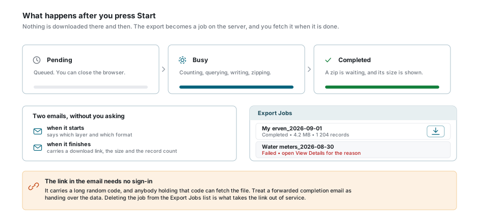
The export runs on the server, so you can keep working and you can close the browser. Two emails arrive without your asking for them: one when the job starts, and one when it finishes, carrying the file size, the record count and a download link.
To fetch the file in the application, open Export Jobs from the arrow beside the Export button or from the wizard's footer, find your job, and press the download button on its row. A job that failed shows its reason under View Details. Statuses, cancelling and troubleshooting are covered in Background Jobs.
The link in the email needs no sign-in
It carries a long random code, and anybody holding that code can fetch the file. Forwarding a completion email is handing over the data. Deleting the job from the Export Jobs list is what takes the link out of service.
What is inside the file
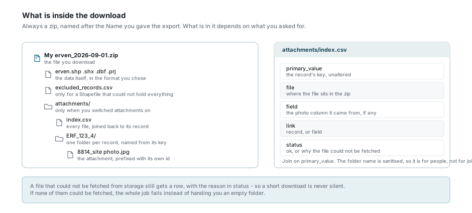
What comes down is always a zip, named after the Name you gave the export, even for formats that are a single file.
Inside it are the data files themselves, plus excluded_records.csv if a shapefile could not hold everything, plus an attachments/ folder if you switched attachments on. Each record's files sit in a folder named after its primary key, with the key run through a sanitiser so that it is a legal folder name on any computer.
attachments/index.csv is the thing to join on. It lists every packaged file against the raw, unaltered primary key of the record it belongs to, says whether the file was attached to the record or held in one of its photo columns, and carries a status column. A file that could not be fetched from storage still gets a row there, with the reason, so a short download is never silent. If none of the files could be fetched, the whole job fails rather than handing you an empty folder.
How much you may export in a month
Your site may set a monthly export allowance for each subscription. Many sites set none, and then nothing in this section applies to you. Where there is one, every completed export counts its records against it, and it resets on the first of the calendar month. Your dashboard shows where you stand as Layer Exports, with your allowance beside it.
An export is all or nothing. When you press Start, the records your export would hold are counted, and if they do not fit in what you have left this month the export is refused there and then, with the numbers: how many records it holds, how many you have left, and your monthly allowance. No job is started and nothing is exported in part. Narrow the export (a filter, a smaller extent, a selection) until it fits, or wait for the month to turn over.
If something looks wrong
| What you see | What it means |
|---|---|
| The Export button is greyed out | The print dialog is open, or a map job is running. Close or finish it. |
| A layer you use is not in the Export Layer list | You have permission to see it but not to download it. Ask your administrator. |
| No Filter box at all | The layer has no saved filters. Nothing is wrong. |
| Next does nothing on step 2 | You are on Features within and have not yet picked both a polygon layer and one of its features. |
| Next does nothing on step 3 | Name is empty, or the format is DXF or KML and its own questions are unanswered. |
| The wizard vanished when you chose an extent | It minimised itself so you can work on the map. Press the window icon in its title bar. |
| Selected Features disappeared | Your map selection was cleared, or you switched to a layer that is not the active one. The wizard moved you back to Features within. |
| A column you ticked is not in the file | That column is exportable but not visible on the layer. Ticking it here cannot override that. |
The file is a .geojson and you asked for something else | You chose one of the eight formats that are not wired through. See the warning under the format list. |
| Your shapefile is missing records | A shapefile holds one geometry type. Read excluded_records.csv in the zip, then re-export as GeoPackage, GeoJSON or KML. |
| Your GPX has points where you expected lines | GPX reduces every feature to a single point. Use a different format. |
| Fewer records than you expected | A filter, the data table's column filters, the Search box, an area limit or your account's own limits applied. Step 4 lists which. |
| More records than the data table lists | One of the starting answers was changed on step 2: the column filters tickbox was cleared, Search was emptied, or a wider extent was chosen. See What the wizard takes from the data table. |
| The wizard opened on Visible extent or All Features | The data table's Visible or Ungeocoded button is on. Choose another extent if that is not what you want. |
| Pressing Start shows "Cannot filter on ..." | The Search box holds an expression naming something that is not a column of the layer. Correct it, or empty the box. See The Search box. |
| "Monthly download quota reached" | This month's completed exports have used up your allowance. Wait for the new month, or ask about a larger subscription. |
| Pressing Start says the export holds more records than you have left | The export does not fit in this month's allowance, so it was not started. Narrow it until it fits, wait for the new month, or ask about a larger subscription. See How much you may export in a month. |
| The download link in an old email still works | It stays live until the job is deleted from the Export Jobs list. |
See also
- Background Jobs - statuses, progress, cancelling and downloading
- Import Layers - the same idea, in the other direction
- Data Table - filtering and selecting before you export
- Attachments - the files the attachment switch packages
- Layer Control - the active layer the wizard opens on